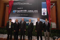
The SERVIR-Himalaya system was being launched today, 5th October, by Mr. Charles F. Bolden Jr., NASA Administrator, and Mr. Michael Yates, Senior Deputy Assistant Administrator of USAID in Kathmandu.
Andreas Schild, Director General of ICIMOD, in his opening words communicated a message from his meeting with the Indian Minister of Environment and Forestry the previous day. First, India is considering ICIMOD as an anchor. Full cooperation of all regional countries and stakeholder is an attainable goal and the window of opportunity is widening.” Secondly, the Minister had emphasized India’s strong support regional cooperation based on strong national institutions.” Schild asked the present organistions to support ICIMOD in its task. He accepted the high obligation that the launch of SERVIR is putting on the organization in serving the stakeholders of the region. “We consider this as a very important and noble task.”
NASA Administrator Charles F. Bolden Jr. started his speech with sharing his experience from his first space expedition, when looking from a height of 600 km he realized that the world really only is one big body of water, which is only periodically interrupted by pieces of land. He explained how the human induced changes in the world have to be measured using all available knowledge sources. This means to combine space-based satellites with in-situ observations to make earth observation a predictive science. That is why NASA has reinvigorated its applied sciences program – to address immediate needs, nine of which have been identified by Global Earth Observation. He welcomed national cooperation between NASA and USAID and international body of GEOSS, to bring together the world’s earth observation agencies. Bolden closed his speech with the words “From space this is a world without borders – we all have a responsibility to cooperate to making our village, our country, our region and this planet a better place.”
The keynote address was delivered by Senior Deputy Assistant, USAID, Michael Yates. He spoke about the present trend within the US administration. “We are all looking for scientific collaboration as a true game-changer and SERVIR is a step into this direction. It combines NASA’s research and technology experience with USAID’s comprehensive development expertise from working with many partners around the world. “According to him, no single government ministry or organization can tackle all the available information offered in the different areas, “that is why SERVIR is the newest node in the vision of a truly global network. It will be powered by electricity but also by trust. We have to understand how people make decisions and how information can feed into that. That is why SERVIR will also bridge the gap to social science research as well.”
Basanta Shrestha, MENRIS Division Head, ICIMOD, had the floor for his presentation on “Bridging the data gap for climate change adaptation in the Hindu-Kush Himalayan (HKH) Region” which related the SERVIR launch back to the overall theme of the International Symposium. Upon outlining the major drivers of Climate Change he explained how it is creating a particular strain on the mountain ecosystem and the downstream areas affected. Mountain communities had demonstrated to be slow in adaptation and that is why ICIMOD’s focus and mission for many years has been to increase the adaptive capacity and resilience of mountain communities. “Our understanding on the complexity of the interlinking issues, however, is still at a very early stage and the HKH has been identified as a data gap region”. That is why ICIMOD is directing its various programs at the different aspects of that knowledge gap, just to name a few: Regional snow monitoring, Regional Mapping and Inventory of Glaciers, Mountain Biodiversity, Mountain Socio-cultural Diversity, Regional and national land cover mapping, Capacity building, Rapid response mapping together with JAXA WINDS, Satellite based Forest Fire Detection and Monitoring, Transboundary air pollution, Reaching the Users through the Mountain GeoPortal and GEOSS. “The way forward is through regional and international cooperation whic
 h will help build synergies between different initiatives and promote the complementary development of a regional database and Himalayan Spatial Data Infrastructure (HSDI).”
The launch ended in the official opening of the SERVIR-Himalaya Network through the present dignitaries.
For more information on SERVIR Himalaya...